Monday, November 28, 2005

La Carta Pisana


This is one of the rare good pictures of La Carta Pisana available in the web.
http://www.capurromrc.it/mappe/!0143pisana.html
The so-called Carta Pisana is considered to be the oldest preserved nautical chart (a map that is made to serve as a sailing aid but it does not have to be used as such)... It is preserved at the Bibliotheque Nationale (Paris).... According to the toponyms (place-names) it is dated to the end of the 13th century. Even though it is called "Carta Pisana" it is widely believed that it was made in Genoa or by a Genoese mapmaker. It is called "Pisana" because it is linked to a Pisan patron.

For those interested in seeing old maps the above mentioned website's got lots of them.

Sunday, November 20, 2005

The amaizing "Google Book Search"

This is spectacular... and I think we're really lucky to witness this moment in the "history of reading"... reading full text books without touching paper...!!!! This experince was already available in restricted websites related to few universities at the US (at Penn we had access to full text books from some time now) but this is clearly a larger and more public project...

So since few weeks the previously announced "Google Book Search" is underway!

Certainly not everything is available yet but many interesting books are already on the web made for free access: For instance I run a search on Tunisia (my home country) and major references (not only the usual absurd touristic guides) came out: Perkins' 2005 History of Modern Tunisia and the interesting book of Gallagher Medicine and Power in Tunisia (2002).

Major refrences are also available like the superb book of Braudel The Mediterranean and the Mediterranean World in the Age of Philippe II....

And most important of all some interesting books on Islamic art and architecture are available...
Notably many issues of Muqarnas, one of the major journals in the field, are available online (it's true that some are already available in archnet but still...)

It's simply amaizing even though the contreversy still going on between Google and major associations of writers and publishers...

Samarra: a forgotten imperial site


The mosque of Mutawakkil in Samarra, the largest in the Islamic world, with its renowned Malwiyya (above); the site of Samarra: 57 Km2 (below)

One of the paradoxes of early Islamic architecture is the limited number of major monuments from the central region of the Caliphate during the most important phase in Islamic architecture that is the early Abbasid period (750-1000 AD).... this is when the Islamic empire reached its most expanded geographic space... when Islamic cities around the centeral space of the Abbasid Caliphate, mainly Iraq with Baghdad as the capital, were the most populated cities in the world... It's a paradox we don't have visible remnants from this space during this exceptional time of urban growth... It's true we have "Abbasid monuments" from other regions like in North Africa where parts of the Ribat of Munastir or the Mosque of Qayrawan date from the second half of the 8th century... but they are mostly originated after the orders of local dynasties like the Aghlabids in these two cases and not by a close supervision of the imperial centre at Baghdad...

A contrast can be made, for exmaple, with the Classical imperial Roman phase (from I Ad to IV AD) from which we have in Rome the capital of the empire, visible until today, the most spectacular Roman monuments...

One of the reasons of this paradox is due to the simple fact of the building materials: at the centre of the empire, Iraq or Mesopotamia, since the earliest times of architectural activities(including the Sumerian and Assyrian times), huge buildings were not made out of cut stones but rather out of softer materials such as bricks... This was the way Assyrian and Abbasid sites (Nineveh and Baghdad alike) were built...

Still our human limitations are part of the reasons: one of them is that we are unable to dig in still populated sites like Baghdad, which is a successfull urban project since it continues to be one of the major cities at least in the region....

But another human reason is that some sites could be forgotten... political circumstances could affect our ability to "remember" them... Samarra is a good example of such forgotten sites...

An imperial Abbasid project that survived only 3 quarters of a century (the 9th century AD) it was meant to move the Abbasid capital from Baghdad to its north western region... The failure of the project provides an unusual opportunity of recovering major data about one of the very important moments of Islamic imperial architecture... The site is impressive in its vastness: 57 Km2... really an imperial site...

Recently (1980s) a Samarra Archeological Survey has been undertaken (by Prof Northedge from Paris I and Dr Kennet from University of Durham)... and now it's in its publication phase... It should bring new important insights about the imperial Islamic urban experience...

See the website of the project with interesting pics:
http://www.dur.ac.uk/derek.kennet/samarra.htm

Friday, November 18, 2005

An online exhibition of Islamic architecture of Cairo

Photo of Bab Zuwayla (Cairo, built in 1092 AD) taken by K. A. C. Creswell: old photographs of architectural monuments are often more informative than new photos since they provide an earlier state of a deteriorating monument

One of the amaizing photographic sources of Islamic monuments in Cairo through time is available online to public view. These are made in the first half of the 20th century by a major specialist, K. A. C. Creswell, in Islamic art and architecture but they are also a good source for introduciung the average viewers to Islamic architecture. Moreover since the photos are from the beginning of the 20th century they allow us to see many monuments in an earlier, then, better state, which makes their analysis more fruitful. In other words old photos in such cases are far more useful than new ones even with the advancements made by new photographic technologies. Obviously if this reflects something it is certainly the dramatic changes in the urban fabrics in Islamic cities in the second half of the 20th century especially those that have an old "medina" as their original focal point.

Something has to be said about Creswell: K. A. C. Creswell (1879-1974) is one of the pioneers of the study of Islamic architecture during the early 20th century, and, therefore, he bears with him the characteristics of that earliest generation: "aventuriers" mostly of military/colonialist backgrounds who sahred a widespread orientalist belief that stigmatized the "Arab" into something bedwin and romantic. For instance Creswell spent some of his life in the British military in India and Egypt and that's how he got interested in Islamic architecture. Still he was very interested in categorizing and, therefore, taking seriously Islamic architecture in a way that made it a field very similar to other European fields in the historiography of architrecture.
His major contribution is a 1932-40 huge publication (two huge volumes with lots of photos) "Early Islamic Architecture", which was later published in a smaller form "A Short Account of Early Islamic Architecture" (1969). Creswell's photographically-staffed publications, somehow, made Islamic architecture VISIBLE. His consistent and miticulous use of the photographic medium left us a huge archival source. This legacy still shines as this online exhbition shows.

A note about the "early Islamic" period (7th to 10th centuries AD): this was for this early generation a major topic since it provided them with the matrial that would enable them to answer their major and, mostly, only question: the "origins" of Islamic architecture. At that time the major task was the very need to "demonstrate" that Muslims had their "own type of architecture" but it was also seen as something that merely combined (without great innovation for many scholars of this generation) pre-Islamic traditions.
For a small biography on creswell see: http://www.islamic-art.org/CreswellExhibition/PDF/Creswell.pdf

So here is the link to the online exhibition...
http://www.islamic-art.org/CreswellExhibition/index.asp

Wednesday, November 16, 2005

Half a Century in the Study of Islamic Art

A new Oleg Grabar's e-publication has been announced.
Oleg Grabar is Professor Emeritus at Harvard University and the Institute for Advanced Study, Princeton. Many view him as the most influential historian of Islamic art and architecture of our day. His numerous publications include The Alhambra, The Art and Architecture of Islam: 650 – 1250, The Formation of Islamic Art, The Great Mosque of Isfahan, The Mediation of Ornament, and The Shape of the Holy: Early Islamic Jerusalem.
http://www.csbe.org/e_publications/islamic_art/islamic_art.htm

Ibn Majid: navigation in Islamic history

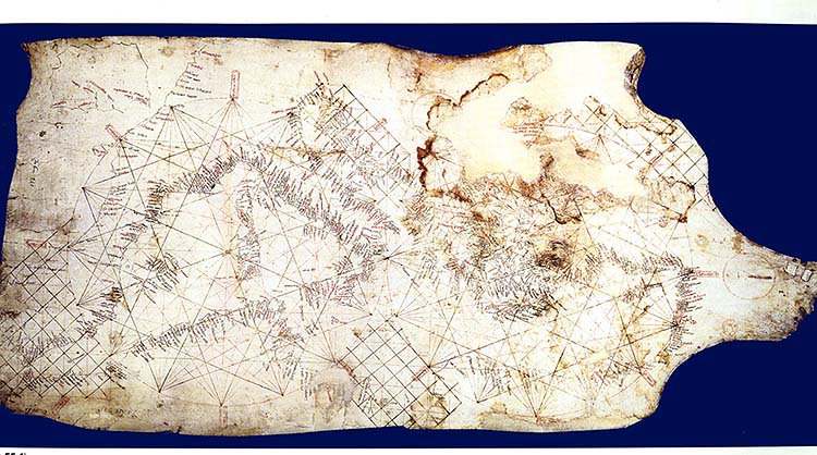
The Tunisian coasts in Agnese's Atlas (1514-65)
(Library of Congress)
Saudi Aramco World has published recently a special issue (July/August) that provides a nice straightforward introduction to non-specialists to the history of Islamic navigation.
http://www.saudiaramcoworld.com/issue/200504/
Ibn Majid obviously is the usual star.
Still some basic questions should have been asked by the author (Paul Lunde): Ibn Majid is known by his writings... No indications has remained pointing to him as a cartographer except for his vague notes on "32 rhumbs": how can he write portolans-like texts (navigational guides) without seeing the need of making a visual presentation of his guides as was the case for the Mediterranean navigators (like Agnese's maps shown above)? Certainly it's still diffcilt to answer this question but it was worth to throw it out...
The most interesting text of the whole issue I think is the small and simple explanation of the Muslims' need, including the navigators, of a solar calendar rather than the Islamic/Hijri lunar calendar:
"The Calendar of Yazdagird and the Rasulid Almanac
A solar calendar was as necessary for navigation as it was for agriculture. The Islamic lunar calendar could not be used, because there was no correlation between the months and the seasons. In Yemen, the Roman Julian calendar was used for agriculture, and a particular form of the Persian calendar was used as a navigational calendar. It was called the Calendar of Yazdagird, after the last Sasanian monarch, Yazdagird III, who established it in 632. This Persian calendar is of great significance, for it was the calendar used in the Middle Ages by Indian Ocean sailors from the Arabic-speaking world.
Year 1 of Yazdagird’s calendar corresponds to 632, and the first day of the year was the summer solstice, June 16. Although the calendar was divided into 12 months, which were given their Persian names, the days of the year were simply numbered consecutively, 1 to 365. This is how Ahmad ibn Majid uses the system to describe a voyage he made in 1471: “We set sail on day 135, only reaching Jiddah after a difficult voyage. We sighted Ra’s Hafun on day 175 and entered the Bab al-Mandab on day 200 against strong northerlies….”
The earliest evidence for the existence of this navigational calendar is an almanac composed in 1271 by the Rasulid sultan of Yemen, al-Malik al-Ashraf. The almanac is based on much older sources, most probably originating in the Gulf port of Siraf, the crucible of early Islamic Indian Ocean navigation. Siraf was destroyed by an earthquake in 977, and the wealthy merchants, shipowners and navigators of the port emigrated, spreading out along the South Arabian, Red Sea and East African coasts. They took with them their capital, their know-how and their networks of international contacts. This diaspora from Siraf had much to do with the growth of ports like Jiddah and Aden. In East Africa it laid the foundations for what became the ports of Mogadishu, Kilwa and Malindi.
The almanac is a perfect example of how the diverse strands of learning that make up classical Islamic civilization were woven into a coherent whole: Month names are in Syriac, derived from Old Babylonian; to these are added Persian month names from the calendar of Yazdagird. The equinoxes and solstices are marked, and the rising and setting of prominent stars and the anwa—constellations whose appearance at dawn heralded rain—are given according to the old Bedouin system. Measurements of shadow lengths throughout the year are included. The days are marked to allow correlation with the Roman Julian calendar. And there is useful information on times to sow and reap, on insect pests, healthy and unhealthy seasons and much more.
The almanac also includes the dates of departure and arrival of ships from India, Qalhat, Hormuz, al-Shihr, Mogadishu and Egypt. This flagging of dates significant to both farmers and mariners shows how the prosperity of the Rasulid dynasty was based on both agriculture and trade.
The entries in the almanac reveal a highly synchronized system of regular shipping among Aden, East Africa and Egypt. The end of the southwest monsoon came with the spring equinox, on Day 65; the entry for Day 68 (March 16) reads, “End of sailing of Indian ships from India to Aden; no one ventures out after this day.” On Day 100 (April 15), the last fleet from India was scheduled to arrive; the arrival of the first ships of the convoy from Egypt, the karim, was timed to coincide with this. The last ships from Egypt arrived on Day 220 (August 14). Six days later, ships from Sri Lanka and Coromandel set out on their voyages home. The last sailing out of Aden on the India run during the northeast monsoon was on Day 250 (September 13). And in addition to these major convoys, there were the ships from the Gulf and East Africa—interregional trade that was also tied in with the oceangoing merchant convoys."

Friday, November 11, 2005

Researching Mss in the Bodleian Library


I just came back from a reaserach-trip at the Bodleian Library/Oxford. The collection of oriental manuscripts is without doubt among the most important in the world. Still few catalogues have been published most of them really old (19th/early 20th), which does not reflect the current list of Mss; especially that the Library is keeping buying wonderful manuscripts. Fortunately a new catalogue of Arabic Mss is being prepared by Dr. Savage-Smith, which should be published by 2007.
Here is a list of the catalogues Arabic/Turkish-Ottoman/Persian Mss with the newest first:
- 2003: Supplementary catalogue of Turkish manuscripts in the Bodleian Library [electronic resource] : with reprint of the 1930 catalogue by H. Ethé / by Günay Kut.
-1958: A descriptive catalogue of the Persian paintings in the Bodleian Library/by Basil Robinson
-1925: The Arabic musical manuscripts in the Bodleian library; a descriptive catalogue with illustrations of musical instruments, by Henry George Farmer.
-1889: Catalogue of the Persian, Turkish, Hindûstânî, and Pushtû manuscripts in the Bodleian Library / begun by Ed. Sachau ; continued, completed and edited by Hermann Eth.
-1845: Catalogi codicum manuscriptorum bibliothecae Bodleianae

Tuesday, November 01, 2005

Astrolabes Exhibition at Oxford

One of the largest collections of Islamic astrolabes is being displayed at the Museum of the History of Sciences at Oxford...
I just saw it and it looks impressive especially the series of North African astrolabes... North African and Sapnish Islamic astrolabes are among the most influential and most beuatiful in the history of astrolabes...
The oldest Islamic piece they have is made in Egypt from the 9th century !!!
The exhibition is interesting also because it's showing the Museum's european collection... The oldest piece is believed to be from the 13th century and was made in Spain... Its most distinguishing features is its resemblence with previous and contemporary astrolabes from Islamic Spain...
The exhibition has just began and will continue until March 12th...
http://www.mhs.ox.ac.uk/